3D Model Helps Tampere Citizens Take Part in Urban Planning
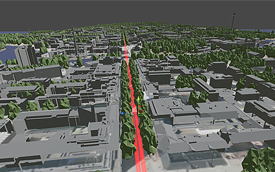
The 3D model of Tampere is a helpful tool for planning urban development, as well as communicating about it. It is a more realistic and accurate alternative to plans on paper in demonstrating how Tampere will evolve in the future. Each user may look up the developments relevant to their own neighbourhood or place of work. This makes it easier for citizens to contribute to urban planning.

– As an example, trees being cleared out of the way of the new tramway construction has upset many people. With this new model, we can show them how the green tracks and the trees that will be planted are going to make the surroundings of the tramway more scenic, says Tero Blomqvist, Smart Tampere Program Director.
The model has been built on the popular Unity gaming engine, which allows the utilisation of new technologies such as augmented or virtual reality to help with user inclusion. Various gamification methods are also used to support the new form of interaction. The long-term objective is for businesses to use the model in developing their services, and for real estate developers to visualise their plans through the model.
The 3D model makes it easier to communicate the big picture. The buildings are scaled properly and the movement of the sunlight imitates reality. The model provides solutions to various needs of urban development by making it possible to plan in locations where physical changes and buildings have not yet been implemented. One example is ensuring that mobile networks reach locations where future constructions may affect their range. In the future, various additional data, such as information on crowd movements, can be implemented into the model.
The plan is to supplement the model with various additional elements over time. The more data on factors such as the appearance of buildings and the visuals of future development projects are added to the model, the more realistic the 3D world becomes.
The model is available at data.tampere.fi, the City of Tampere’s new data portal, which is used to share the city’s open data with businesses, educational institutions and private persons.
– The initial version of the model only displays the surroundings of the future tram line, or the Hervanta, Tampere University Hospital and city centre areas. In addition to the tramway, the model displays other projects which are being planned or under construction. The model will continue to be developed and expanded in the future, says Joonas Dukpa, the Project Manager in charge of the City of Tampere’s open data.
The Tampere 3D Model was created as a part of the Smart Tampere programme’s project called The Six City Strategy: Utilising mass data in urban and traffic development, and as an innovation platform for services and businesses. The project is a joint, two-year venture by the City of Tampere, the City of Helsinki, and the University of Tampere, and its purpose is to develop user-driven services together with partner companies using mass data. The project is funded by the European Regional Development Fund, and it is a part of the Six City Strategy (6Aika), in which six major Finnish cities have come together to develop new open and smart services.
Link: Mapping service view of the 3D model
Link: 3D model in the City of Tampere data portal


Leave a Reply